Premise nearby Estadio Ferrocarriles
Coronavirus disease (COVID-19) Situation
confirmed cases
5384853
deaths
64497
Chile
Premise nearby Estadio Ferrocarriles
Estadio Ferrocarriles
Santiago, Estación Central, Santiago Metropolitan Region, Chile
contacts phone
:
+56
Latitude:
-33.4716977
, Longitude:
-70.6748417
larger map & directions
read more
nearest Premise
232 m
Empresa de Ferrocariles del Estado Maestranza San Eugenio
Santiago
Premise
read more
538 m
Plaza Arauco
Santiago
Premise
read more
1.483 km
Ex - Penitenciaría
Santiago
Premise
read more
1.917 km
San Francisco de Borja 402
Santiago
Premise
read more
2.018 km
Hall Geología
Santiago
Premise
read more
2.203 km
Unión Latinoamericana 151
Santiago
Premise
read more
2.212 km
Placer 1410
Santiago
Premise
read more
2.254 km
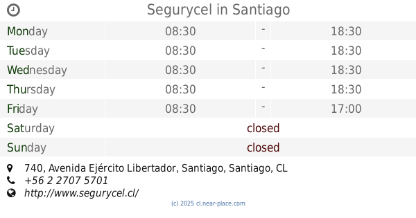
Segurycel
Avenida Ejército Libertador 740, Santiago, Santiago
Premise
read more
2.257 km
Serviteca Goodyear
Pedro Aguirre Cerda
Premise
read more
2.695 km
Aparcamento
Santiago
Premise
read more
2.725 km
Av Libertador Bernardo O'Higgins 2206
Santiago
Premise
read more
2.884 km
Gran Avenida Jose Miguel Carrera 3300
San Miguel
Premise
read more
2.908 km
Gran Avenida Jose Miguel Carrera 3548
San Miguel
Premise
read more
2.918 km
Cibercafé
Pedro Aguirre Cerda
Premise
read more
2.933 km
Auditorium Miguel León Prado
San Miguel
Premise
read more
3.004 km
Ferretería El Nano
Pedro Aguirre Cerda
Premise
read more
3.074 km
Unidad Vecinal Portales
Santiago
Premise
read more
3.161 km
Cienfuegos 41
Santiago
Premise
read more
3.385 km
Palacio Campino
O'Higgins, Avenida Libertador Bernardo O'Higgins 1452, Santiago, Santiago
Premise
read more
3.474 km
Torre Entel
Hermanos Amunátegui 20, Santiago
Premise
read more
3.655 km
Pinturas Renner
Los Cerrillos
Premise
read more
3.849 km
Direccion de Fronteras y Limites
Santiago
Premise
read more
4.582 km
Convento Santo Domingo
Santiago
Premise
read more
5.094 km
Palacio Bruna
Merced 230, Santiago, Santiago
Premise
read more
5.333 km
Edificios Turri
Providencia
Premise
read more
📑
all categories
Accounting
Administrative area level 1
Administrative area level 2
Airport
Amusement park
Aquarium
Art gallery
Atm
Bakery
Bank
Bar
Beauty salon
Bicycle store
Book store
Bowling alley
Bus station
Cafe
Campground
Car dealer
Car rental
Car repair
Car wash
Casino
Cemetery
Church
City hall
Clothing store
Colloquial area
Convenience store
Country
Courthouse
Dentist
Department store
Doctor
Electrician
Electronics store
Embassy
Establishment
Finance
Fire station
Florist
Food
Funeral home
Furniture store
Gas station
General contractor
Grocery or supermarket
Gym
Hair care
Hardware store
Health
Hindu Temple
Home goods store
Hospital
Insurance agency
Intersection
Jewelry store
Laundry
Lawyer
Library
Light rail station
Liquor store
Local government office
Locality
Locksmith
Lodging
Meal delivery
Meal takeaway
Mosque
Movie rental
Movie theater
Moving company
Museum
Natural feature
Neighborhood
Night club
Painter
Park
Parking
Pet store
Pharmacy
Physiotherapist
Place of worship
Plumber
Point of interest
Police
Political
Post office
Premise
Real estate agency
Restaurant
Roofing contractor
Route
Rv park, camping
School
Shoe store
Shopping mall
Spa
Stadium
Storage
Store
Sublocality
Subpremise
Subway station
Supermarket
Synagogue
Taxi stand
Train station
Transit station
Travel agency
University
Veterinary care
Zoo
administrative area level 3
administrative area level 4
administrative area level 5
sublocality level 1
sublocality level 2
sublocality level 3
sublocality level 4
↑